New Trail Would Keep Adirondacks “Forever Wild”
Sustainable trail design protects nature and shows off the value of wilderness
Image credit: Tara Holley, using elements from Jessica Andreone, Ellen Brown, and Unsplash
by Jessica Andreone
January 18, 2022
The Adirondack Park just got bigger. Spanning the mountain range it’s named after, the Adirondack Park is more than 6 million acres—outsizing Yellowstone, Everglades, Glacier, and Grand Canyon National Parks put together. Although the 250 acres on the south side of Moxham Mountain might seem like a small addition—after all, one could drive four hours and still be within the boundaries of the Adirondack Park—the newly acquired land might provide an opportunity to ease an ongoing national park challenge.
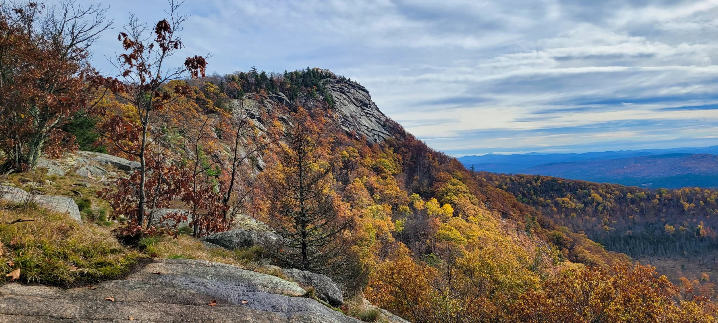
Image credit: Jessica Andreone
Every year, millions of tourists migrate to New York’s Adirondack mountain peaks during the hiking season from late spring through early fall. The original Adirondack trails were designed before hiking became a sport and sustainable trail design was an idea. In recent years, outdoor sports have become more popular. The increased volume of tourists using recreational areas has caused a deterioration of rare and endemic animals and plants living in the mountains and a steep decline in trail conditions. But the previous landowners of the park’s new land, located on the south side of Moxham Mountain, left the area undeveloped, so it has been untouched by the constant stampede of nature enthusiasts. The New York State Department of Environmental Conservation (DEC) and the Student Conservation Association (SCA) have a chance to create a new recreational area with long-lasting trails that can withstand heavy foot traffic while protecting wildlife.
The mountain, part of the Vanderwhacker Mountain Wild Forest, is a pristine wilderness made of northern hardwood trees and a steep, rocky outcrop that towers 2,361 feet at its summit. This land is about 20 miles south of the famous High Peaks Wilderness region of the Adirondacks and is less hiked, with stunning views of rolling peaks and the crisp, blue water of small lakes and the Hudson River.
“Nobody has ever built on it,” said Mary Thill, communications manager for the Adirondack Land Trust. This nonprofit organization focuses on protecting farmlands and wild places within the Adirondack Park. According to Thill, the Brassel and Zack families bought the land in the 1950s and wanted to conserve it. When the land trust purchased the 250 acres in 2019, it acted as a liaison to carry the parcel into state ownership.
Erin Hanczyk, the DEC public participation specialist for Moxham Mountain’s region, said in an email that adding this parcel of land to the Adirondack Forest Preserve protects it as a “forever wild” space under Article 14 of the New York State Constitution.
“Trails may cut through the wilderness, but they also help protect nature.”
The land trust purchase happened after the DEC and SCA opened a trail on the north side of Moxham Mountain in 2012. According to Hanczyk, work on the newest addition has not yet begun. The Adirondack Park Agency must classify the land, assign it a management unit, and approve proposals through a unit management plan amendment before any trail building can begin. The plan must undergo an environmental impact assessment that aligns with the State Environmental Quality Review Act to examine and prevent any significant environmental risks associated with the proposal. This process looks out for waterways, nesting birds of prey, and rare wildlife in the proposed project area. But once the designated land has been through this review process, trail builders will get to work.
Zac Ballard, the manager of the SCA Adirondack Corps trail crew from 2008 to 2013, said, “The state had acquired a new piece of property and got to the top of the mountain, and they kind of identified that as something that people would inevitably want to get to.”
As an SCA staff member, Ballard led small groups into the Adirondack wilderness for days at a time to create and manage rural trails.
“It’s a challenge to think of what tools we need to get the job done to make us the most efficient in the field without taking every single tool under the sun,” said Ballard. “It can often be 100 pounds of tools, and that’s in addition to gear that you may be using to camp at your worksite and all the food you would need to stay at your worksite.”
Megan Gorss, an Adirondack trail work and infrastructure intern for the SCA and DEC who spent two summers fixing trails in the Adirondack front country, said carrying a chainsaw didn’t make sense because of the weight of the protective equipment, the gas, and the saw itself. Not to mention, these crews might bear that load and not even need it once they reached their work area.
Instead, she relied on a one-hand saw approximately 18 inches long and a two-hand saw with a blade almost 2.5 feet long. Other trail tools included shovels, buckets, loppers, and McLeods—instruments with flat heads perpendicular to the handle that can shape and pack down soil, with one edge sharpened to cut through roots and the opposite end decorated with prongs to act as a rake. Crews only used wheelbarrows if the trail conditions allowed it.
When planning a trail, builders must think like hikers, considering topography and drainage. Hikers want a path with the fewest inclines and declines and as straight as possible. A switchback—a path that zigzags to reach a higher point on a slope—is excellent for creating a sustainable trail that is more resistant to washouts than a straight ascent. But, if hikers on a switchback see their destination, they may go off-trail and create a shortcut.
Hikers will wander off a marked trail to avoid territory they would rather not cross. Not many people are fans of dredging through the mud, so trekkers walk around the outskirts of muddy paths. It seems innocent enough, but over time, the trail widens. Compacted soil from heavy foot traffic makes it harder for protected plants to grow. Thus, little by little, habitat degrades.
“A trail at Seneca Rocks in West Virginia, which was finished with crushed stone and lots of switchbacks, had fencing and interpretive signs saying, ‘Please don’t take shortcuts,’ because of the soil erosion,” said Gorss. Despite the precautions, the barren dirt made it apparent that hikers were disregarding the signs. Undesignated or unplanned paths created by the repeated stomping of trekkers are known as social trails. When management teams plan sustainable paths that suit the needs of the explorers that travel them, fewer social trails develop.

Pink lady's slipper (Cypripedium acaule). Image credit: Peter Gorman via Flickr
Ideally, crews would make trails out of materials that offer drainage and are hard to erode, such as large portions of exposed rock that make up the mountain itself or a substance known as mineral soil. Mineral soil can’t hold much water because it lacks organic content. This form of dirt is often found on-site by workers just by going slightly off path and digging into a patch of earth.
As stewards create trails, they plan to create a pathway that will lead up a mountain, following the contours of geographic formations with only an 8%-10% incline. Ballard says most of the courses in the High Peaks region rest in what is known as a fall line, the shortest possible ascent from the bottom to the top of a mountain, which is often a steep ascent. He pointed out that a genuinely sustainable trail would wrap itself around the hill on a path that isn’t as steep but isn’t much longer than a fall-line trail, protecting hikers, plants, and geographical features alike.
Though Moxham Mountain is not in the High Peaks Wilderness, where rare alpine plants have particular adaptations to survive a rocky and exposed climate, it is still home to a broad range of vegetation. A mix of birches, sugar maples, American beech, red spruce, eastern hemlock, white ash, and black cherry create a dense canopy perfect for understory growth. This mixture allows soils to sustain ferns, mosses, fungi, and vulnerable plants like pink lady’s slipper.
Where plants and fungi thrive, other life follows. Birds, squirrels, deer, raccoons, brown bats, beavers, bears, and even moose depend on habitats like those found in Vanderwhacker Mountain Wild Forest. Plans to change protected land need to consider every level of the food chain before work can begin—a vital step since trail crews and outdoor enthusiasts will engage with the environment throughout the lifespan of the path.
Ballard said he was building bridges in an area called Crested Ponds when he and his crew had to work around two young male loons. The team needed to cross two ponds to get to their worksite, and the loons would chase them down. “We would start out in the morning on one pond. And these two male loons would fly in front of our boat and essentially follow us the entire way, calling, chattering, flapping their wings, diving under the water, and being extremely aggressive,” said Ballard. “We’d get out at the other side of the pond, drag the boat, get back into the boat, and we would see these loons fly to the next pond, land, and continue the same thing. This happened every single day, morning and evening, for seven days straight.”
Trails may cut through the wilderness, but they also help protect nature. “For me, it provides an opportunity to experience wonder and curiosity and cultivate a sense of respect for things that live there,” said Gorss.
Gorss explained that the sense of wonder that drives people to the outdoors protects it because an area becomes more valuable if people can use it. If people could not access nature, they would see it as vacant land to be harvested for timber or developed for businesses. Trails, as a monetary resource, can mean tourism, boosting local economies.
So, excluding people from nature to save it isn’t an option. Instead, the DEC High Peaks Strategic Planning Advisory Group released a report in early 2021 recommending that recreation within the region be made more sustainable to address the increase in visitation. Within the report, the group recommended creating a new unit within the DEC to handle recreation and data collection to determine the carrying capacity of trails and parking lots. Some of these efforts were already in the DEC’s plans.
Whether the new trail will help with the Adirondacks’ overuse issue or instead draw more crowds to the area remains to be seen. A new trail project promises a healthier balance between recreation and preservation with these issues in mind as outdoor exploration continues to boom.
Jessica Andreone
Jessica Andreone focuses her writing on parks, conservation, ecology, and history. When Jessica is not writing, taking photos of birds, or taking her cat on hikes, she is the communications assistant for The Olana Partnership, a nonprofit that supports Frederic Church's home.